
It’s The Journey… Right?
Road trips can be a great way to find yourself, see parts of the world not usually seen by tourists, and, all around, a fun way to spend time with loved ones. Of course, getting stuck in hours-long traffic does tend to dampen the mood, which is common enough when you stick to some of the more well-known highways. Check out this list to figure out which ones you should avoid, and where to head instead.

1. Interstate-90
Interstate-90 is the longest interstate highway in the United States, stretching west to east for almost 3,100 miles. You start your journey in Seattle, Washington and end in Boston, Massachusetts. Taking this iconic route will take you past national parks, historical sites, and the beauty of the western cordillera.
2. Causeway Coastal Route
The Causeway Coastal Route is a 121-mile-long highway that takes you alongside the coast of Northern Ireland. You can start your journey at either Belfast or Derry, and the route connects to the Wild Atlantic Way and the Mourne Coastal Route, which you can take around Ireland at large.
 Amar Prakash Pandey on Unsplash
3. Foothills Parkway
This national parkway is located in eastern Tennessee and offers a 72-mile scenic drive through the Great Smoky Mountains National Park. The parkway is the only one of seven 1944 congressionally mandated highways that has not been finished. 22.5 miles are open and available to the public, making this jaunt a lovely day trip.

4. Interstate 81
Interstate 81 is a north-south highway that stretches 855 miles across the eastern part of the United States. You start in Dandridge, Tennessee, and end on Wellesley Island, New York, just short of the Canadian Border. This trip will take you through Roanoke, Hagerstown, Harrisburg, Wyoming Valley, Binghamton, and Syracuse.

5. Route des Crêtes
The Route des Crêtes is a 55-mile road located in the Vosges Mountains of Eastern France. The road connects the towns of Sainte-Marie-aux-Mines with Cernay, and offers glorious scenic views as you drive 3,117 feet above sea level. The road is usually closed in the winter due to snow and strong winds.

6. Crowsnest Highway
Crowsnest Highway is a western Canadian staple that runs east-west from Hope, British Columbia, to Medicine Hat, Alberta. The highway is the shortest connection through the Canadian Rockies, stretching about 720 miles. Flying down the Crowsnest will show you coastal mountain views to the flat, prolonged grasslands of the prairies.
 User Mjrogers50 on en.wikipedia on Wikimedia
7. Route 212
Also known as Beartooth Highway, Route 212 is a small portion of the larger US Route 12, running east-west for 949 miles. You start your journey in Yellowstone National Park and end in Edina, Minnesota. This highway will take you through mountain peaks, glaciers, and alpine lakes, climbing over 10,000 feet at Beartooth Pass.

8. The Trans-Canada Highway
The Trans Canada Highway is the ultimate road trip route for a Northern adventure. It runs from the eastern-most province of the country, starting in St. John’s in Newfoundland and Labrador, ending in either Victoria or Haida Gwaii in British Columbia. The highway spans 4,645 miles and will take you through all 10 provinces of Canada.

9. Darling River Run
The Darling River Run is a road trip staple that takes you across 590 miles of the Australian outback. You’ll pass through several towns and National Parks as you make your way through the province of New South Wales, all while being accompanied by the rush of the Darling River.

10. Million Dollar Highway
The Million Dollar Highway is a subset of U.S Highway 50. It runs north-south, starting in Bernalillo, New Mexico to Montrose, Colorado, taking you across 305 miles of Western America. The highway gets its name from its original 19th-century purpose of transporting miners to the silver mines via horse and buggy.
 Carol Highsmith's America on Unsplash
1. Pacific Coast Highway
Also known as California State Route 1, this 656-mile-long highway is famous for its stunning ocean views and picturesque towns. However, driving through the southern part of this highway can get extremely busy, as it’s close to Los Angeles and Malibu.

2. Nandi Hills
Nandi Hills is a 37-mile-long highway that takes you from Bengaluru to the town of Nandi Hills in India. It’s full of history and gorgeous mountain views, but is usually full of people, making parking difficult. The highway also regularly comes into contact with wildlife areas, meaning you have to exercise caution while driving.

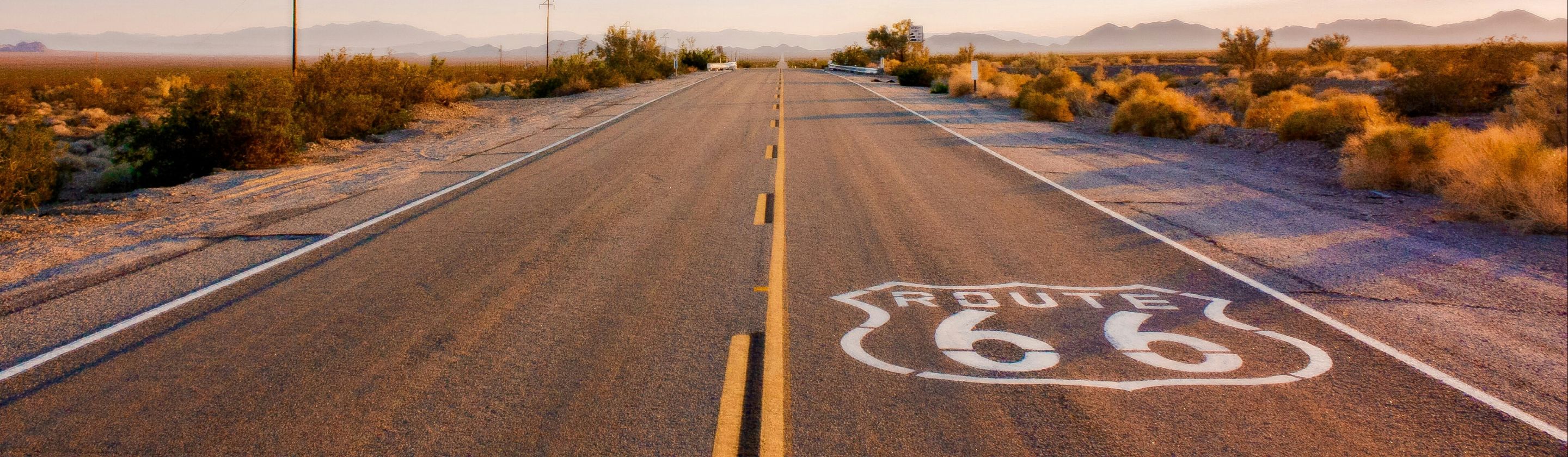
3. Route 66
It’s not quite the journey it once was. Route 66 takes you from Santa Monica, California to Chicago, Illinois, stretching across 2,448 miles. The highway still exists, but it’s become quite desolate and is no longer maintained, losing out to the Interstate Highway System all the way back in the 1950s.

4. Road To Hana
The Road to Hana is a 64-mile drive on the northeastern coast of Maui, Hawaii. Due to its overwhelming popularity and promise of gorgeous island views, the single-lane highway is often a bumper-to-bumper experience rather than a meandering cruise.

5. The Pan-American Highway
The Pan-American Highway is one of the longest roads in the world, stretching 19,000 miles from Prudhoe Bay, Alaska, to Ushuaia, Argentina. Beautiful in theory, but the highway is blocked by the Darién Gap - a 66-mile stretch of rainforest between Panama and Colombia. If you want to continue your journey either way, you have to go around the Darién Gap by land or sea.

6. Blue Ridge Parkway
The Blue Ridge Parkway is a 469-mile road that links Ravensford, North Carolina to Rockfish Gap, Virginia. It’s considered the longest linear park in the United States, but its popularity can mean dealing with some pretty intense traffic.

7. Lake Pontchartrain Causeway
This Louisiana staple is an almost 24-mile-long bridge that connects Metairie and Mandeville. It’s a gorgeous way to pass over a large body of water, but travelers have noted that it gets quite monotonous after a while. The causeway is also very narrow, meaning you can’t pull over to snap that scenic photo.
 Grant L. Robertson or employee on Wikimedia
8. 17-Mile Drive
This scenic road is located on California’s Monterey Peninsula and is full of beaches, golf courses, mansions, and plenty of natural beauty. However, it costs almost $12 to enter the drive and has become something of a tourist trap.

9. The Autobahn
The Autobahn is Germany’s national highway system, and is well-known for having unrestricted speed limits on almost half of its stretches. That said, going for a drive on infrastructure that is used primarily for commuting means you’ll often get stuck in some pretty congested areas.

10. Skyline Drive
The Skyline Drive is a 105-mile-long road that runs north-south in Shenandoah National Park. It’s the only public road through the park and does have some pretty exquisite views of Virginia, but you’ll be fighting a 35mph speed limit, large crows, and limited access to gas, water, and food.